


Mid-seasonal tropical cyclone activity forecast for 2020


Typhoon is a covered peril on all property policies in China. Since 2015, Peak Re has partnered with the Shanghai Typhoon Institute (STI) to monitoring tropical cyclones (TC) in the North West Pacific Basin (NWP) and South China Sea (SCS). Peak Re to issue two reports each year, one for the pre-cyclone season and the other as a mid-season review.
These reports use state-of-the-art statistical and climactic modelling to conclude a mid-long term forecast of typhoon activity compared to the long term climate average (LTCA). The information allows underwriters or risk managers to understand cyclones’ risks better and manage the risks with a reliable scientific reference.
Forecast summary
Based on current climatic conditions and activity in 2020 to date, this report forecasts:
- The formation of 25-27 tropical storms1 in the North Western Pacific Basin and the South China Sea in 2020.
- 14-15 tropical cyclones2 are forecast to impact China in 2020 which is above the long term climate average. However, tropical cyclones impacting South and East China are forecast to be more active than the long term climate average, of which;
- 10-12 are forecast to impact South China;
- 10-13 are forecast to impact East China;
- Seven to nine are forecast to make landfall over China which is slightly above the long term climate average.
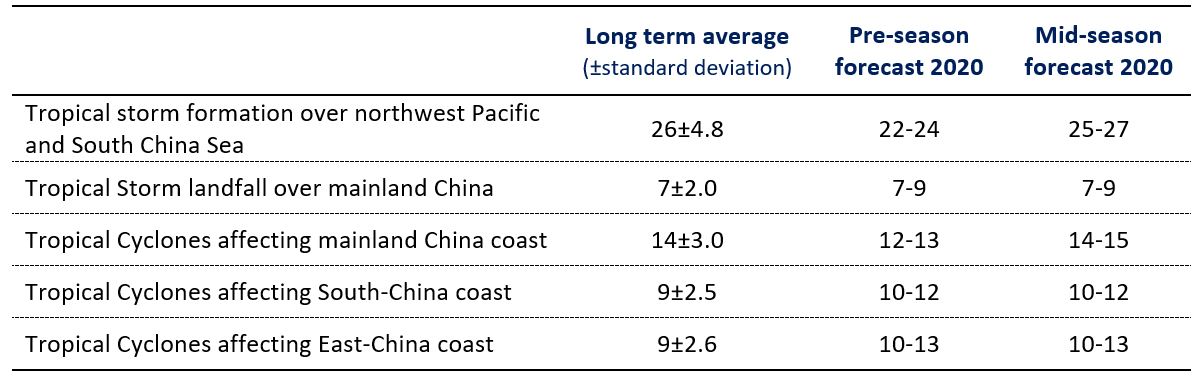
Table 1. 2020 seasonal forecasting of TC activity
The mid-season report for 2020 forecasts within the normal range formation of tropical storms (TS) and tropical cyclones over the northwest Pacific and South China Sea. Table 2 showed an explanation of tropical storm classification.
The forecast of tropical cyclones impacting mainland China overall for 2020 is within a normal range of the long term climate average. However, the number of tropical cyclones making landfall or impacting South and East China is forecast to be slightly more active than the long term climate average (see Table 1).
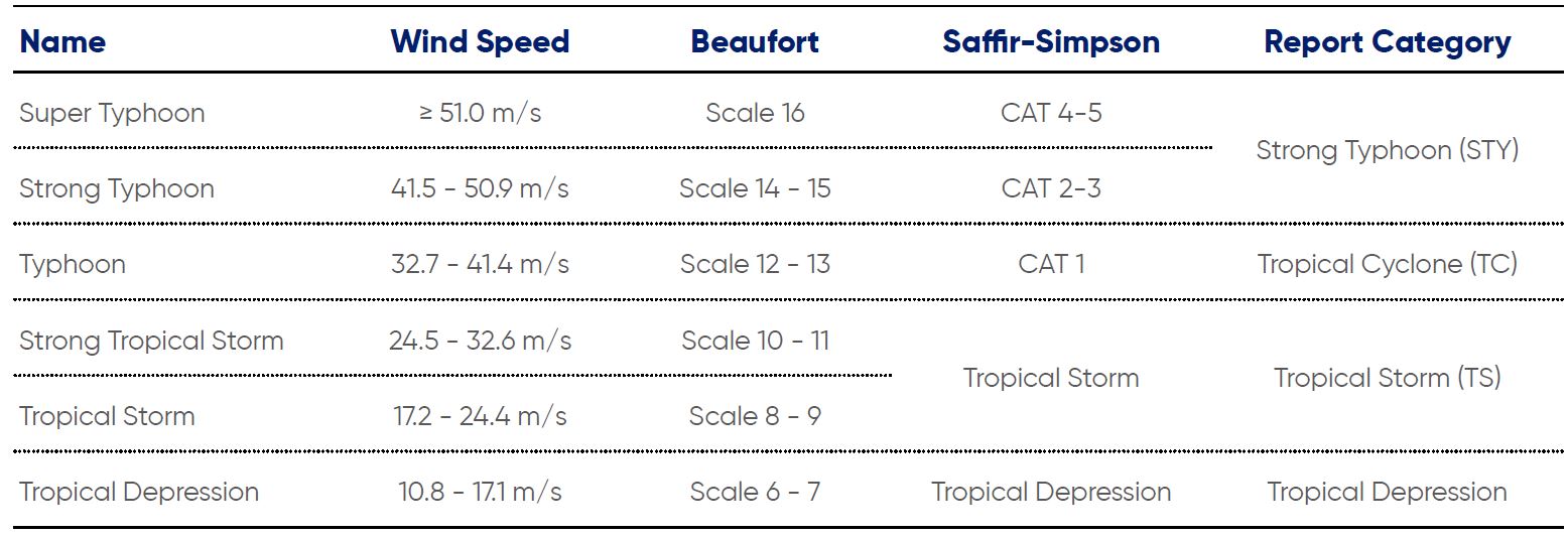
Table 2: Tropical storm classification
- Tropical cyclone with tropical storm or higher scale
- Tropical cyclone with tropical depression or higher scale
Terms Definition
- TC Landfall – Tropical Cyclones with minimal Tropical Storm Strength when making landfall in China
- Significant Affect – Within one of the three conditions
- Aggregate precipitation in the given area of over 50mm
- Average wind of scale 7 (or gust* over scale 8) in given area
- Aggregate precipitation of over 30mm and an average wind over scale 6 (or gust* over scale 7) in given area
- South China – Guangdong, Guangxi, Hainan
- East China – Fujian, Jiangxi, Zhejiang, Anhui, Shanghai, Jiangsu, Shandong
- Tropical Cyclone Scale – Details in GB/T 19201–2006
- Wind Speed – Average maximum wind speed within 2 minutes near the eye wall of the tropical cyclone
* Gust wind speed is approximately 1.2-1.5 times of MAWS depends on the TC location and meteorological conditions (WMO)
更多文章


选择鼎睿
为您保驾护航
为您保驾护航