


Tropical cyclones formation shifts eastward with a slightly stronger intensity – 2018 Tropical Cyclone activity updates

农险险核保主管
Following the forecast in April 2018, Peak Re and Shanghai Typhoon Institute (STI) released the August updated seasonal forecast of tropical cyclone activities over Western North Pacific (WNP) and South China Sea (SCS).
2018 August cyclone activity forecast
In the forecast, the expected number of tropical cyclones formation in 2018, as well as the number of events which impacts the whole of China have remained unchanged from the report in April.
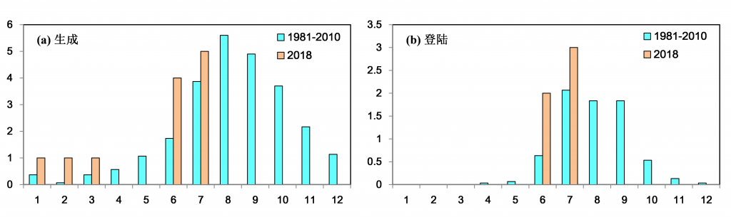
Fig. 1 Comparison of long term average formation (left) and landfall (right) to 2018 actual (January to July)
However the overall number of landfall of tropical cyclones over China and its impact on South China was revised downward slightly while the number of tropical cyclones impacting Eastern China was revised slightly higher.
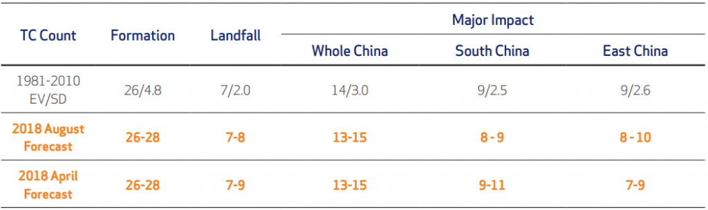
Table 1. Forecast of Tropical Cyclone (TC) Activity
(This report includes TC with Tropical Storm scale or above within WNP and SCS)
Half season summary
1. Higher formation and landfall in China and Japan
There were no events formed in April and May, however the formation in other months were higher than historical normal level. Landfall events were more concentrated during June and July.
There were four events making landfall over the main Japan islands at the end of July where the number is higher than the long term average.
2. More westerly and scattered formation
As at end of July, about 60% of the events formed over the ocean to the west of longitude 130 degrees.

Fig 2. Location of formation from January to July (green dot) and long term historical formation (shaded areas, 1981 to 2010)
3. Less strong events and shorter lifetime
Only two events reached “severe typhoon or above” scale and the figure is below long term average. The average lifetime of 2018 cyclones to date is 4.9 days which is also shorter than the long term average.
However, the duration of depression stage of some events (No 1/4/6/16) is much longer than the duration of intensified stage when forming to tropical storms.
Second half year outlook
Since the spring of 2018, the Sea Surface Temperature (SST) stayed normal and the weak La Nina event ended. The SST over east tropical Pacific Ocean remains at neutral status now, and is trending to become warmer. (Fig 3)
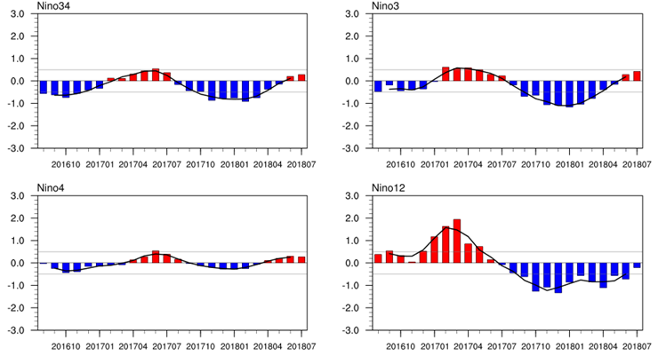
Fig 3. SST movement
The dynamics of atmospheric circulation over Eastern Asia and its impact to the SST over Northwest Pacific basin will change, due to the status of mid-east tropical Pacific Ocean SST changed from below normal to above normal (Fig3). As a result, tropical cyclone activity during this autumn is expected to be formed at more eastward areas and with a slightly stronger intensity during its lifetime.
Starting from June and July, intensity of Northwest Pacific monsoon is higher than average which provides a better environment for the cyclone formation. A more north and westward located sub-tropical high pressure system also leaves huge vacant areas in South China for cyclones to travel a more westerly track.
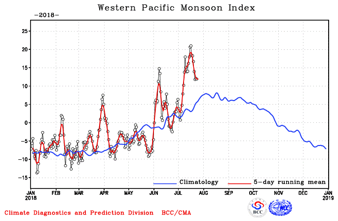
Fig 4. Western pacific summer monsoon index development (from NCC)
Summary
Therefore more attention needs to be placed on the tropical cyclone impact to Eastern China, Japan and South Korea. More importantly, as the positive anomaly is observed over Tropical Pacific Ocean together with a northerly located subtropical high system, we also need to pay more attention of the events that travels more flat track with long range intensifying which could impact Philippines, South China and even Vietnam.
The original forecast was published in August 2018, so no reference to subsequent events is made.
Seasonal Tropical Cyclone Activity Forecast Report (Aug 2018)
更多文章


选择鼎睿
为您保驾护航
为您保驾护航